Where to Go Hiking in Toronto
Let’s go over all the trails and parks where it’s best to go hiking in Toronto and get to know the city on a deeper level.
Want to get to know the city on a deeper level while getting a little workout and enjoying the scenery? We call that a triple win. Time to hit the trails in and around the city. Find some new favourites in our list of best places to hike in Toronto. Or, venture a little further out to select your next weekend outing.
Scarborough Bluffs Park
These tall, crumbly cliffs used to be the ancient shore of Lake Ontario during the last Ice Age. Now they’re a fantastic place to go hiking without leaving the 6ix. Head to Bluffer’s Park beach at 1 Brimley Road South to access the Scarborough Bluffs trail. At about 6,400 metres long with minimal elevation gain and loss, it’s not too challenging and affords stunning views of Toronto’s Great Lake.
Did you know? The Scarborough Bluffs is made up of 11 parks. Find the best park for your interests.
Rouge National Urban Park
Another fantastic hiking spot off Lake Ontario, Rouge National Urban Park surrounds the mouth of the Rouge River, where Indigenous peoples settled and farmed for at least 10,000 years. There’s a lot to do and see here—the Toronto Zoo is right next door and there’s Rouge beach at the far end of the park downriver. But some of the park’s best features are its hiking trails.
The Glen Eagles Vista Trail is an easy 600-metre hike that has incredible views of the river’s path through the landscape. The Mast Trail is a five-kilometre favourite, for more experienced hikers, that takes off from the Glen Rouge Campground through some of the Park’s diverse scenery before connecting to the Orchard and Vista trails.
The Toronto Carrying-Place Trail is an old Mohawk portage route that continues to have significance for local Indigenous tribes.
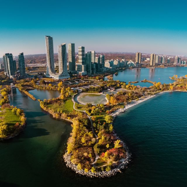
Enjoy the beautiful skyline view while taking the trail through Humber Bay Park
Humber River Recreation Trail
The Humber River Trail is a largely level, paved route that cuts for 25 kilometres from Thackery Park to Humber Bay on Lake Ontario. That’s a lot to tackle in a day, especially if you’ve got a stroller. So try an easy to moderate portion of the hiking trail that cuts from the Humbermeade neighbourhood at the north end of Toronto all the way down past the Lambton Golf Club and on nearly as far as Bloor West Village.
You may also like: The Nature Lover’s Guide to Humber Bay Shores
Moore Park Ravine
Thanks to the Rouge and other area rivers, not to mention the movements of ancient glaciers, there is a vast system of ravines throughout Toronto. Moore Park is tucked into one of these, and you can explore on the Moore Park Loop Trail, a roughly six-kilometre path through Toronto’s beautiful Carolinian forests. There are some fun sites along the way, like where the 1920s pylons of the Governor’s Bridge cross the trail.
Tommy Thompson Park
Tommy Thompson Park encompasses a long narrow peninsula into Lake Ontario with the Toronto Harbour Lighthouse at its tip, and you can see the whole thing from end to end on a multi-use paved nature trail. The five-kilometre path is easily accessible for those with strollers or mobility aids, as well as cyclists and rollerbladers. A pedestrian-only mown grass track next to the nature trail covers a smaller area of Tommy Thompson, but can offer a more secluded hiking experience
Tommy Thompson Park is also well known for cycling. Learn about the top cycling routes in Toronto.
Taylor Creek Park
The Don River is formed where the East Don, the West Don, and Taylor Creek meet in a three-pronged fork, and Taylor Creek Park’s eponymous trail traces the path of that later tributary. The three-kilometre trek is paved on one side of the river and a more traditional dirt hiking trail on the other side. There are numerous bridges that cross portions of the ravine and Taylor Creek, too, so you have a lot of fun photo ops and chances to see the landscape from different vantage points. If you’re lucky, you’ll get to see wildlife from songbirds to beavers, too.
Lynde Shores Conservation Area
Just beyond Toronto proper, Lynde Shores Conservation Area offers all sorts of ways to get out into nature, from a canoe launch to five kilometres of hiking trails. It’s also connected to the Great Lakes Waterfront Trail, a massive 3600-kilometre trek that runs from Collingwood on the Georgian Bay of Lake Huron to Detroit, Buffalo, Hamilton, Toronto and on to the Quebec-Ontario border partway up the St. Lawrence River. The three-kilometre portion that passes through Lydne Shores is paved, and suitable for outdoor enthusiasts with disabilities.
High Park
Close to trendy Bloor Street, High Park shows off some of the best of Toronto’s ecosystems and landscapes, from Black Oak savannah to Carolinian forests to the city’s network of ravines. The Spring Creek Ravine, Western Woodlands and Western Ravine High Park nature trails are three great hikes in the park. Volunteers and naturalists regularly offer walking tours through the park if you want to learn more about Toronto’s unique ecology or make some new friends on your hike.
Toronto Islands
It’s well worth the ferry ride to the Toronto Islands if you want prime lakefront hiking. This 14-kilometre hike (one way) leads from the Ward Island ferry terminal on the northern city side of the Islands all the way to the Hanlan Point Ferry Terminal on the opposite side of the crescent sandbar.
Hike the whole thing and you’ll have a chance to see Hanlan Beach, the Gibraltar Point Lighthouse, the arched bridge between Centre and Middle Islands, the Centreville Amusement Park, and the cute beach bungalows of Ward’s Island.